-
Recent Posts
- Takin’ a break
- Bureau of Military History 1913-1921 II
- Bureau of Military History 1913-1921 I
- Australian Newspaper Articles II
- British Newspaper Articles
- US Newspaper Articles IX
- Canadian Newspaper Articles
- Rev. Richard Buggy c.1802-1864
- US Newspaper Articles VIII
- Insolvencies in Kilkenny 1830
- Sergent’s Tragic Homecoming 1952
- Assistant Mine Foreman 1918
- Dorchester, MA Tax Records 1869
- The Land Purchase Act Advances 1916
- Schuylkill County Civil War Volunteer
- Irish Newspaper Articles II
- Kings County Surrogates Court 1684 – 1923
- K.T. Buggy – Archive Listing
- Married in Washington DC 1844
- Manchester, England Catholic Parishes
- Mill Renter, Delaware County, PA
- A load of old manure
- Ellis Island Wall of Honor
- Accusation of illegal voting 1888
- Guinness Employment Records c.1880-2000
- Arson in Cavan 1886
- Assisted Emigration Castlecomer Estate, Kilkenny 1847-1853
- Holahan & Buggy, Waukon, Iowa
- 3rd Battalion Kilkenny 1922
- Irish Teachers Union 1874
- Report of the O’Connell Monument Committee 1888
- Evicted Tenants Fund, Laois, Ireland 1882 & 1883
- Irish Newspaper Articles I
- New York City Directories 1849 &1850
- New York City Directory 1871
- 1832 Kilkenny Conviction
- Buggy – the worst character 1855
- Belfast Riots 1886
- Pigot and Co.’s Provincial Directory of Ireland 1824
- Outburst Against English Catholics 1929
- 11th Century
- 14th century
- 17th Century
- 18th Century
- 19th Century
- 20th Century
- 1790 Census
- 1800 Census
- 1810 Census
- 1820 Census
- 1830 Census
- 1840 Census
- 1860 Census
- 1901 Census
- 1911 Census
- Antrim
- Boston
- Breconshire
- Buckinghamshire
- California
- Carlow
- Castlecomer
- Christchurch
- Colorado
- Connecticut
- Cork
- District of Columbia
- Down
- Dublin
- Galway
- Georgia
- Grey Mouth
- Illinois
- Iowa
- Kerry
- Kildare
- Kilkenny
- Lancashire
- Laois
- Limerick
- Liverpool
- London
- Louisiana
- Louth
- Maine
- Massachusetts
- Meath
- Michigan
- Middlesex
- Minnesota
- Missouri
- Montana
- Nebraska
- New Jersey
- New York
- New York City
- Nova Scotia
- Offaly
- Ohio
- Ontario
- Ossory
- Pennsylvania
- Philadelphia
- Quebec
- Rhode Island
- South Carolina
- Surrey
- Tipperary
- Toronto
- Vermont
- Virginia
- Washington
- Waterford
- Wicklow
- Wisconsin
-
Join 14 other subscribers
Categories
- Australia (7)
- Canada (7)
- Census (14)
- Church Records (5)
- Court Records (18)
- Directories (8)
- Employment Records (2)
- England (12)
- Ireland (50)
- Land and Estates (3)
- Local History (5)
- Maps (10)
- Military (12)
- Naturalization (2)
- New Zealand (2)
- Newspaper (25)
- Passenger List/ Ship Manifest (3)
- Personal Correspondence (4)
- Rest of World (3)
- Scotland (5)
- Subscription List (1)
- Taxation Records (1)
- Uncategorized (2)
- US Census Series (7)
- USA (54)
- Vital Records (8)
- Voting and Freeholders (4)
- Wales (4)
- Will and Administration (5)
Archives
- August 2012
- July 2012
- June 2012
- May 2012
- April 2012
- March 2012
- February 2012
- January 2012
- December 2011
- November 2011
- October 2011
- September 2011
- August 2011
- July 2011
- June 2011
- May 2011
- April 2011
- March 2011
- February 2011
- January 2011
- December 2010
- November 2010
- October 2010
- September 2010
- August 2010
- July 2010
- June 2010
- May 2010
Category Archives: Maps
Census of Canada 1851
A census of population was carried out across much of the British Empire in 1851. Canada was included as it was part of the empire at the time. The areas enumerated were Canada East (most of current Quebec), Canada West … Continue reading
Posted in Canada, Census, Maps
Tagged 19th Century, New Brunswick, Nova Scotia, Ontario, Quebec
Leave a comment
US Census 1910 (VII)
In terms of the number of states represented, the 1910 census shows a slight decrease on the 1900 census, down to 17 states and DC from 21 states and DC. However the number of Buggy’s increases to what I believe … Continue reading
Posted in Census, Maps, US Census Series, USA
Tagged 20th Century, California, Connecticut, District of Columbia, Illinois, Iowa, Massachusetts, Michigan, Minnesota, Missouri, Montana, Nebraska, New Jersey, New York, Ohio, Pennsylvania, Virginia, Washington, Wisconsin
Leave a comment
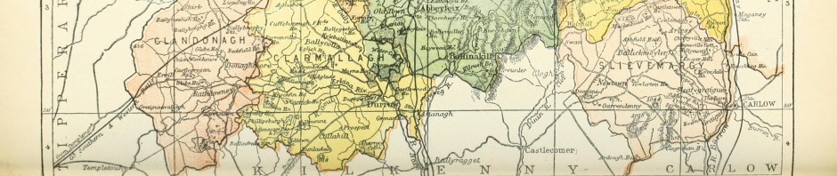
Map of Census of Ireland 1901
I have previously outlined the number of times that the Buggy name appears in the counties of Ireland in the 1901 census. To accompany this I have created a map to show the location of every Buggy that is listed. … Continue reading
US Census 1900 (VI)
We have to skip the 1890 census in this series as it was destroyed by a fire in the Commerce Building in 1921 in Washington DC. Unfortunately, only the records for 6160 people have survived from a population at the … Continue reading
Posted in Census, Maps, US Census Series, USA
Tagged 1900 Census, 20th Century, California, Colorado, Connecticut, District of Columbia, Illinois, Iowa, Louisiana, Massachusetts, Michigan, Military and Naval Forces, Minnesota, Missouri, Montana, Nebraska, New Jersey, New York, Ohio, Pennsylvania, Rhode Island, Tennessee, Vermont, Virginia, Washington
Leave a comment
Census of England, Scotland and Wales 1841
The 1841 census was the first to be carried out after the 1836 General Registration Act and as a result it was carried out by the Registrar General. It became a more complete census than those that had gone before … Continue reading
Posted in Census, England, Maps, Scotland, Wales
Tagged 19th Century, Breconshire, Buckinghamshire, Lancashire, Middlesex, Surrey
Leave a comment
US Census 1880 (V)
The 1880 census saw a sharp decrease in the number of states that had Buggy’s living in them, down from 19 to 13. Total numbers increased to 251.[1] A Buggy presence is re-established in California, with Montana listed for the … Continue reading
Posted in Census, Maps, US Census Series, USA
Tagged 1880 Census, 19th Century, California, Connecticut, Illinois, Iowa, Massachusetts, Minnesota, Missouri, Montana, New Jersey, New York, Ohio, Pennsylvania, Virginia
1 Comment
US Census 1870 (IV)
The 1870 census shows a further change in the distribution of those with the Buggy name in America. There is a steady 8% increase from 223 to 243 people with the name.[1] The name also continues with its north east … Continue reading
Posted in Census, Maps, US Census Series, USA
Tagged 1870 Census, 19th Century, Connecticut, Florida, Georgia, Illinois, Indiana, Iowa, Massachusetts, Michigan, Missouri, New Hampshire, New Jersey, New York, North Carolina, Ohio, Pennsylvania, South Carolina, Vermont, Virginia, Wisconsin
Leave a comment
US Census 1860 (III)
The US census of 1860 shows a considerable jump in the number of people who have the Buggy name, up from 97 to 223 in 10 years.[1] This was due to child birth and immigration, mostly from Ireland. In this … Continue reading
Posted in Census, Maps, US Census Series, USA
Tagged 1860 Census, 19th Century, Alabama, Arkansas, California, Connecticut, Illinois, Iowa, Massachusetts, Missouri, New Jersey, New York, Ohio, Pennsylvania, Vermont, Virginia
Leave a comment
US Census 1850 (II)
The census of 1850 was the first one that listed every member of the household by name and is therefore a very important genealogical resource. All numbers listed are families unless otherwise stated. There were 97 people in total with … Continue reading
Posted in Census, Maps, US Census Series, USA
Tagged 1850 Census, 19th Century, Connecticut, Illinois, Massachusetts, New Jersey, New York, Ohio, Pennsylvania, Vermont, Virginia, Wisconsin
Leave a comment
Names from England Map 1086-1280
I have created a map of England which shows some of the earliest documented examples of Buggy and similar names. The line drawn across the country shows the extent of Viking settlements. These settlements were located in the counties north … Continue reading
Posted in England, Maps
Tagged 11th Century, 12th Century, 13th Century, Armscote, Buttermere, Gloucester, Nottingham, Viking, Yorkshire
Leave a comment
